
FAQ
- Local shops in Artarmon Local Centre.
- Trains, metro and buses at Chatswood Transport Interechange, St Leonards Transport Interchange, Artarmon Train Station, Crows Nest Metro Station
- Businesses in the Chatswood, Artarmon Industrial Area and St Leonards
- The RMS Bicycle Guidelines which indicate that widths of shared paths should be between 2 and 3 metres (which aligns with AUSTROADS Guide to Traffic Engineering Practice Part 14: Bicycles); and
- The AUSTROADS Guide to Road Design Part 6A: Paths for Walking and Cycling which indicates that a local path should be between 2 and 3 metres.
- 10 m statutory No Stopping on approach/ departure to intersection applies
- Statutory and TfNSW policies for No Stopping on approach to and departure from traffic signals and other traffic devices
- 1 m clearance on either side of a driveway
- 5.5 m per car space in unmarked road lengths – this is the existing situation
- 6.5 m per space for marked bays to comply with Australian Standard. The length of marked bay may be shorter at start and end bays. This car space length is applied to median separated sections only. The length is to provide a space that permits a typical medium – large car to park and door openings are not impacted by medians i.e. medians are not trip hazards for vehicle occupants
- In bicycle path sections, parking is unmarked and therefore is the same as existing.
- Desktop road and footpath measurements;
- Related Council and NSW Government plans;
- Policies and technical guidelines;
- Constraints in the study area; and
- Site inspections.
- The RMS Bicycle Guidelines which indicate that widths of shared paths should be between 2 and 3 metres (which aligns with AUSTROADS Guide to Traffic Engineering Practice Part 14: Bicycles); and
- The AUSTROADS Guide to Road Design Part 6A: Paths for Walking and Cycling which indicates that a local path should be between 2 and 3 metres.
What are the benefits of this proposal
A bicycle route linking Chatswood with St Leonards via Artarmon is identified in Council’s Bike Plan 2012.
The current route and proposed facilities are considered to provide the safest, direct, accessible and most amenable bicycle route for local residents, commuters and visitors.
The route enables a north-south cycle link to:
The bicycle link will improve the safety for bicycle riders along the route by physically separating cyclists from vehicles.
The bicycle route will connect to existing east-west bicycle routes such as the shared path along the Gore Hill Freeway via Punch Street and the planned shared path along Frederick Street to key places of interest for work, education and leisure along the way.
Why has this bike route been chosen?
Willoughby City Council is creating a bicycle network that is suitable for all riders, including those that may not be as confident riding on-road.
A link between Chatswood CBD and St Leonards CBD was identified in Council’s Bike Plan 2012 and confirmed in the Bike Plan Review in 2017. This route will also form part of the wider Transport for NSW Principal Bicycle Network.
The route will improve north-south connectivity and enhance access to east-west routes within Willoughby that link Chatswood CBD to the wider Willoughby cycling network and further into Lane Cove Council and North Sydney Council LGA’s.
A route option investigation and assessment was undertaken as part of a detailed study of bicycle links that may be able to link Chatswood and St Leonards. The route was chosen as it is the most direct, provided the best riding conditions, good connectivity and was located close to or passed through important destinations.
The route will connect to existing facilities such as the shared path along the Gore Hill Freeway. This route will connect to key places of interest, such as places of work, education or leisure.
What is a concept design?
A concept design is a document prepared in the early stages of a project to develop and test an idea and, if supported, to guide detailed planning. A concept design may undergo changes before being finalised.
What is a detailed design plan?
A detailed design is a design that is based on engineering survey and provides an accurate representation of the proposed changes. The detailed design is used to construct the approved changes.
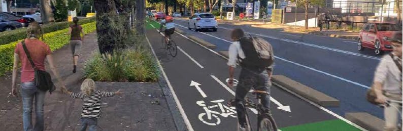
What is a median separated bicycle lanes?
Median separated bicycle lanes can either be uni-directional (physically separated bike lanes that allow bicycle movement in one direction on one side of the street) or bi-directional (physically separated bike lanes that allow bicycle movement in both directions on one side of the street).
The Bicycle Route detailed design plans proposes to have a bi-directional physically separated facility along Hampden Road and Herbert Street. The design uses median separated bi-directional bicycle lanes.
What is a two way bicycle path?
A two way bicycle path is a design that has the footpath and the bicycle path at the same level. The footpath and bicycle path is typically separated by trees, landscaping and other measures.
The detailed design plan incorporates the use of two way bicycle path.
What is a shared path?
A shared path is a path that can be used by people for walking and cycling. Shared paths are often provided when there is no space for a protected bike path and road conditions are not ideal for riding. On shared paths, people on bicycles are expected to give way to people walking, ring the bell and slow down. Additional signage and pavement markings can be used to improve shared path safety for all users.
Is there enough room for pedestrians and people on bikes to use the shared path?
The shared path will be developed according to:
What about impacts to on-street parking?
The detailed design plan will have an impact to the current available on-street parking. The detailed design plan indicates a loss of around 15 spaces spread along the route. The proposal impacts on parking on both sides of both roads.
The estimate of existing total number of spaces along Hampden and Herbert Street, east side of road only, excluding the Artarmon Local Centre (Brand to Jersey) is 177 car spaces.
Draft detailed design car parking spaces
The estimate of existing total number of spaces along Hampden and Herbert Street, east side of road only, excluding the Artarmon Local Centre (Brand to Jersey) in the draft detailed design is 174 car spaces
The estimated net loss of existing number of spaces along Hampden and Herbert Street, west side of road only, excluding the Artarmon Local Centre (Brand to Jersey) in the draft detailed design is 8 car spaces (a loss of 8 car spaces)
The following factors were used in assessing street parking impacts in the detailed design plan:
Is this the final revision of the detailed design plan?
No. The detailed design on public exhibition is a draft only, and no decision has yet been made by Council. A decision will be made only once all feedback has been considered.
What information was used to develop the Bicycle Route Improvement Plan?
The draft Bicycle Route Improvement Plan and concept design was developed following identification of a key route that would link Chatswood CBD to St Leonards in Council’s 2012 Bike Plan Review and an analysis of existing conditions and options.
The analysis of existing conditions and options included:
Is there enough room for pedestrians and people on bikes to use the shared path?
The shared path will be developed according to:
Is there a speed limit for cyclists using the shared path?
The
advised speed on a shared path is 30km/h. However the actual speed is based on
the context of the shared path surroundings. A slower speed environment will be
provided for areas of high pedestrian activities such as around bus shelters
and commercial and retail centres.
What happens if I want to pass someone or they want to pass me on the shared path facility on a bike?
Road user rule of keeping left is advised along the shared path. A directional shared path marking will be provided as well as a centre line to encourage the appropriate and safe user behaviour. Overtaking therefore is expected to be conducted in a safe manner.
How is user safety considered for driveways?
In high conflict areas, paint, markings and signs will be utilised to warn people that they are approaching an upcoming conflict area, and to be aware that other modes of transport may be around.
Will I have other opportunities to provide feedback?
Yes. Feedback can be provided using the survey in this page.
What else is Council doing to make it better for people to ride bikes?
Council is also developing plans for other bicycle routes. As bike routes become more connected and continuous, riding a bicycle will continue to become safer, more convenient and more comfortable.
Council offers a number of events to promote cycling in Willoughby. Regular bicycle maintenance workshops and cycling skills sessions are held for families, beginner, intermediate and commuter cyclists throughout the year. Council also supports Bike Week and Ride to Work Day which take place late in the year.
Will construction disrupt access to property/services along the route?
Disruptions will be kept to minimum as practicably as possible. Access however will not be
restricted during the construction period.
What measures were investigated but not included in the current plan?
The section of the route along Frank Channon Walk between Albert Avenue and Nelson Street is an established shared path and there are no proposals to change Frank Channon Walk in this location.
A new shared path link between Nelson Street and Mowbray Road is to be provided as part of the Sydney Metro City and Southwest project. The design of the shared path is still under development by Sydney Metro. The new shared path link forms part of the route. Community consultation of this new link will be undertaken by Sydney Metro.
Bicycle Route improvements along Hampden Road between Brand Street and Jersey Road, Artarmon was investigated.
The Artarmon Local Centre is being investigated holistically as part of an Artarmon Local Centre Public Domain Concept Plan (ALCPDCP).
Integration of the bicycle route along Hampden Road is being developed within the ALCPDCP. The design of the bicycle route between Brand Street and Jersey Road is not provided. The design process for the ALCIP is progressing with community consultation to be undertaken separately.
What sections of the route are not part of this community consultation process?
The following sections of the bicycle route
The section of the route along Frank Channon Walk between Albert Avenue and Nelson Street is an established shared path and there are no proposals to change Frank Channon Walk in this location.
A new shared path link between Nelson Street and Mowbray Road is to be provided as part of the Sydney Metro City and Southwest project. The design of the shared path is still under development by Sydney Metro. The new shared path link forms part of the route. Community consultation of this new link will be undertaken by Sydney Metro.
The Artarmon Local Centre is being investigated holistically as part of an Artarmon Local Centre Public Domain Concept Plan (ALCPDCP). Integration of the bicycle route along Hampden Road is being developed within the ALCPDCP. The design of the bicycle route between Brand Street and Jersey Road is not provided. The design process for the ALCPDCP is progressing with community consultation to be undertaken separately.